
Thank you for supporting this site ❤️
Make a donation
Make a donation
Pucioasa topographic map
Click on the map to display elevation.
Thank you for supporting this site ❤️
Make a donation
Make a donation
About this map
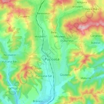
Name: Pucioasa topographic map, elevation, terrain.
Location: Pucioasa, Dâmbovița, Romania (45.03584 25.39527 45.12912 25.49979)
Average elevation: 474 m
Minimum elevation: 354 m
Maximum elevation: 727 m
Thank you for supporting this site ❤️
Make a donation
Make a donation
Other topographic maps
Click on a map to view its topography, its elevation and its terrain.