
Thank you for supporting this site ❤️
Make a donation
Make a donation
Iowa City topographic map
Click on the map to display elevation.
Thank you for supporting this site ❤️
Make a donation
Make a donation
Iowa City
The elevation at the Iowa City Municipal Airport is 668 ft (203.6 m) above sea level.
Thank you for supporting this site ❤️
Make a donation
Make a donation
About this map
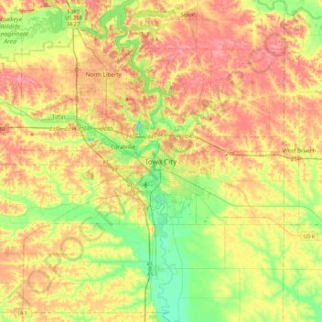
Name: Iowa City topographic map, elevation, terrain.
Location: Iowa City, Johnson County, Iowa, 52240-5544, United States (41.50126 -91.68991 41.82126 -91.36991)
Average elevation: 225 m
Minimum elevation: 182 m
Maximum elevation: 269 m
Thank you for supporting this site ❤️
Make a donation
Make a donation