
Make a donation
Ghimbav topographic map
Click on the map to display elevation.
Make a donation
Ghimbav
The town is situated in the southern part of the Transylvanian Plateau, at an altitude of 559 m (1,834 ft), on the banks of the river Ghimbășel. It is located in the Burzenland ethnographic area, in the central part of Brașov County, just 8 kilometres (5 mi) west of the county seat, Brașov.
Make a donation
About this map
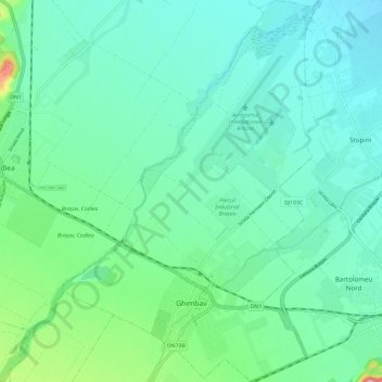
Name: Ghimbav topographic map, elevation, terrain.
Location: Ghimbav, Zona Metropolitană Brașov, Brașov, 507075, Romania (45.64662 25.46699 45.72817 25.54456)
Average elevation: 544 m
Minimum elevation: 511 m
Maximum elevation: 674 m
Make a donation
Other topographic maps
Click on a map to view its topography, its elevation and its terrain.
Postăvaru
The Postăvarul massif (Transylvanian German Schuler and Schulerberg, or Hungarian Keresztényhavas) is a massif in Romania; it is part of the Romanian Carpathians, which in turn are part of the Carpathian Mountains range. The altitude of the highest peak, also named Postăvarul is 1799 metres.
Average elevation: 1,362 m
Make a donation
Make a donation
Make a donation
Make a donation
Make a donation
Make a donation
Make a donation