
Thank you for supporting this site ❤️
Make a donation
Make a donation
Zango III topographic map
Click on the map to display elevation.
Thank you for supporting this site ❤️
Make a donation
Make a donation
About this map
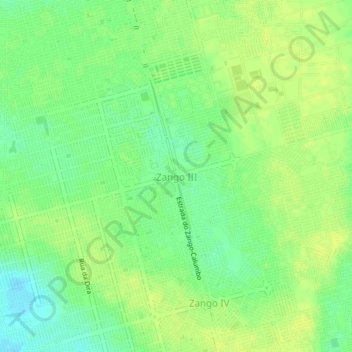
Name: Zango III topographic map, elevation, terrain.
Location: Zango III, Viana Municipality, Luanda Province, Angola (-9.06810 13.39188 -9.02810 13.43188)
Average elevation: 150 m
Minimum elevation: 139 m
Maximum elevation: 156 m
Thank you for supporting this site ❤️
Make a donation
Make a donation
Other topographic maps
Click on a map to view its topography, its elevation and its terrain.
Thank you for supporting this site ❤️
Make a donation
Make a donation
Thank you for supporting this site ❤️
Make a donation
Make a donation
Samba Urban District
Angola > Luanda Province > Municipality of Luanda > Luanda
Average elevation: 41 m
Thank you for supporting this site ❤️
Make a donation
Make a donation
Thank you for supporting this site ❤️
Make a donation
Make a donation
Thank you for supporting this site ❤️
Make a donation
Make a donation