
Make a donation
Forest Acres topographic map
Click on the map to display elevation.
Make a donation
About this map
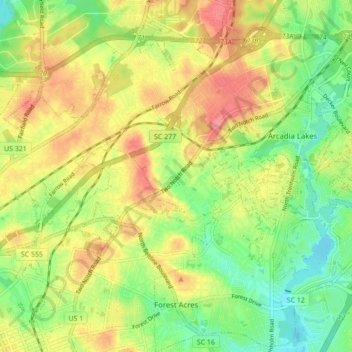
Name: Forest Acres topographic map, elevation, terrain.
Average elevation: 85 m
Minimum elevation: 47 m
Maximum elevation: 126 m
Make a donation
Other topographic maps
Click on a map to view its topography, its elevation and its terrain.
Forest I At Harbison
United States > South Carolina > Richland County > Columbia
Average elevation: 87 m
Harbison State Forest
United States > South Carolina > Richland County > Columbia
Average elevation: 79 m
Make a donation
Sesquicentennial State Park
United States > South Carolina > Richland County
This park offers three picnic shelters, four picnic pads, and 84 campsites that vary in amenities & sizes. The park provides rental fishing boats, paddle boats, standup paddleboards, kayaks, canoes, fishing access to the 30-acre (12 ha) park lake, and four trails providing over 12 miles (19 km) of recreational…
Average elevation: 97 m
Make a donation
Forest I At Harbison
United States > South Carolina > Richland County > Columbia
Average elevation: 87 m
Riverbanks
United States > South Carolina > Richland County > Columbia > Riverbanks
Average elevation: 69 m
Make a donation