
Thank you for supporting this site ❤️
Make a donation
Make a donation
Gisting Atas topographic map
Click on the map to display elevation.
Thank you for supporting this site ❤️
Make a donation
Make a donation
About this map
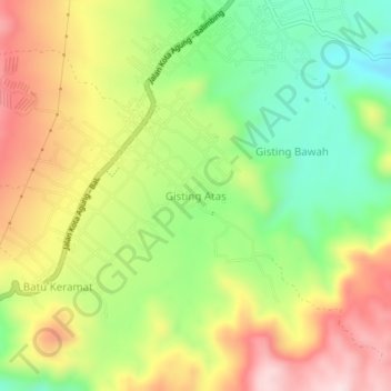
Name: Gisting Atas topographic map, elevation, terrain.
Location: Gisting Atas, Tanggamus, Lampung, Sumatra, Indonesia (-5.46280 104.70776 -5.42280 104.74776)
Average elevation: 582 m
Minimum elevation: 408 m
Maximum elevation: 781 m
Thank you for supporting this site ❤️
Make a donation
Make a donation
Other topographic maps
Click on a map to view its topography, its elevation and its terrain.