
Gilmer County topographic map
Interactive map
Click on the map to display elevation.
About this map
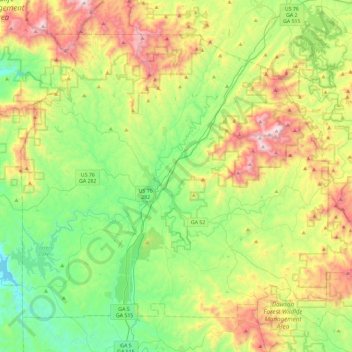
Name: Gilmer County topographic map, elevation, terrain.
Location: Gilmer County, Georgia, Vereinigte Staaten von Amerika (34.54830 -84.65759 34.85545 -84.19477)
Average elevation: 570 m
Minimum elevation: 208 m
Maximum elevation: 1,258 m
Other topographic maps
Click on a map to view its topography, its elevation and its terrain.
Mountaintown
Vereinigte Staaten von Amerika > Georgia > Gilmer County > Mountaintown
Mountaintown, Gilmer County, Georgia, Vereinigte Staaten von Amerika
Average elevation: 467 m