
Pulau Sorenarwa topographic map
Interactive map
Click on the map to display elevation.
About this map
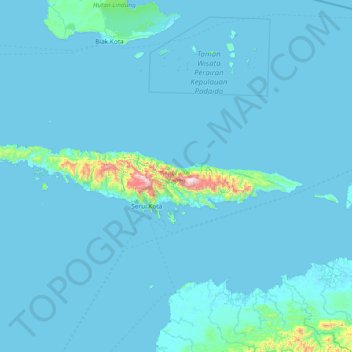
Name: Pulau Sorenarwa topographic map, elevation, terrain.
Average elevation: 39 m
Minimum elevation: -1 m
Maximum elevation: 1,434 m
Other topographic maps
Click on a map to view its topography, its elevation and its terrain.
Banawa
Indonesia > Papua > Yapen Islands Regency > Serui Kota
Banawa, Serui Kota, Yapen Islands Regency, Papua, Western New Guinea, 98211, Indonesia
Average elevation: 55 m