
Thank you for supporting this site ❤️
Make a donation
Make a donation
Pardee topographic map
Click on the map to display elevation.
Thank you for supporting this site ❤️
Make a donation
Make a donation
About this map
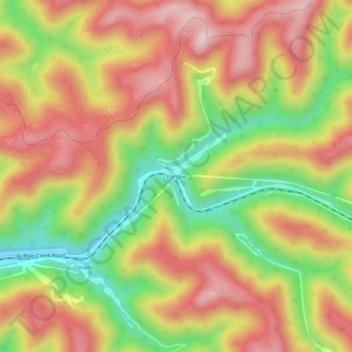
Name: Pardee topographic map, elevation, terrain.
Location: Pardee, Logan County, West Virginia, 25630, United States (37.78594 -81.72150 37.82594 -81.68150)
Average elevation: 581 m
Minimum elevation: 357 m
Maximum elevation: 769 m
Thank you for supporting this site ❤️
Make a donation
Make a donation
Other topographic maps
Click on a map to view its topography, its elevation and its terrain.
Greenville
United States > West Virginia > Logan County > Greenville > Hensley Heights
Average elevation: 371 m
Thank you for supporting this site ❤️
Make a donation
Make a donation