
Thank you for supporting this site ❤️
Make a donation
Make a donation
Jelgava topographic map
Click on the map to display elevation.
Thank you for supporting this site ❤️
Make a donation
Make a donation
About this map
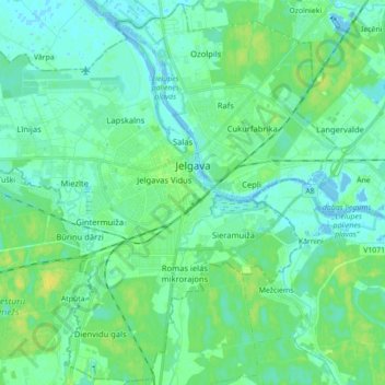
Name: Jelgava topographic map, elevation, terrain.
Location: Jelgava, Latvia (56.59687 23.62350 56.69184 23.79957)
Average elevation: 5 m
Minimum elevation: -5 m
Maximum elevation: 17 m
Thank you for supporting this site ❤️
Make a donation
Make a donation
Other topographic maps
Click on a map to view its topography, its elevation and its terrain.
Alūksne
Latvia > Vidzeme > Alūksnes novads
Alūksne (German: Marienburg)) is a town on the shores of Lake Alūksne in northeastern Latvia near the borders with Estonia and Russia. It is the seat of Alūksne municipality. Alūksne is the highest elevated Latvian city, located in East Vidzeme Upland at 217 m above sea level. The high elevation of the…
Average elevation: 187 m
Thank you for supporting this site ❤️
Make a donation
Make a donation
Thank you for supporting this site ❤️
Make a donation
Make a donation
Strautiņu mācību un pāraudzināšanas iestāde
Latvia > Vidzeme > Alūksnes novads
Average elevation: 137 m
Thank you for supporting this site ❤️
Make a donation
Make a donation
Thank you for supporting this site ❤️
Make a donation
Make a donation
Thank you for supporting this site ❤️
Make a donation
Make a donation
Thank you for supporting this site ❤️
Make a donation
Make a donation
Thank you for supporting this site ❤️
Make a donation
Make a donation
Thank you for supporting this site ❤️
Make a donation
Make a donation
Thank you for supporting this site ❤️
Make a donation
Make a donation
Thank you for supporting this site ❤️
Make a donation
Make a donation
Thank you for supporting this site ❤️
Make a donation
Make a donation
Thank you for supporting this site ❤️
Make a donation
Make a donation
Thank you for supporting this site ❤️
Make a donation
Make a donation
Thank you for supporting this site ❤️
Make a donation
Make a donation
Thank you for supporting this site ❤️
Make a donation
Make a donation
Thank you for supporting this site ❤️
Make a donation
Make a donation