
Pananawan topographic map
Click on the map to display elevation.
About this map
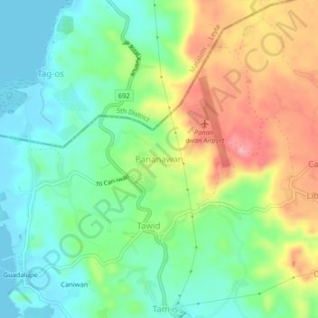
Name: Pananawan topographic map, elevation, terrain.
Average elevation: 48 m
Minimum elevation: 0 m
Maximum elevation: 125 m
Other topographic maps
Click on a map to view its topography, its elevation and its terrain.
Limasawa
Limasawa was the second island (after Suluan) of the Philippines that the Magellan Expedition landed on. Antonio Pigafetta documented the island as "Mazaua". He described it as being inhabited with cultivated fields. In March 28, 1521 the Magellan Expedition met with two rulers, Rajah Colambu and Rahah Siaui,…
Average elevation: 1 m