
Thank you for supporting this site ❤️
Make a donation
Make a donation
Musson topographic map
Click on the map to display elevation.
Thank you for supporting this site ❤️
Make a donation
Make a donation
About this map
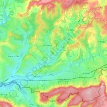
Name: Musson topographic map, elevation, terrain.
Location: Musson, Virton, Luxembourg, Wallonie, 6750, Belgique (49.53883 5.61661 49.60779 5.73472)
Average elevation: 298 m
Minimum elevation: 223 m
Maximum elevation: 408 m
Thank you for supporting this site ❤️
Make a donation
Make a donation
Other topographic maps
Click on a map to view its topography, its elevation and its terrain.