
Dapa topographic map
Click on the map to display elevation.
About this map
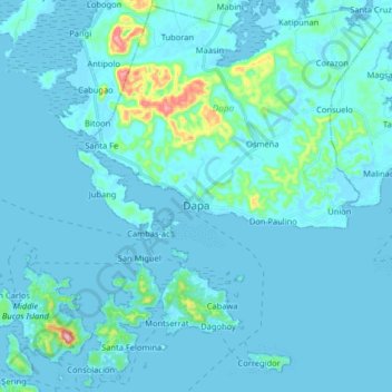
Name: Dapa topographic map, elevation, terrain.
Location: Dapa, Surigao del Norte, Caraga, 8417, Philippines (9.68290 125.96647 9.83813 126.12803)
Average elevation: 19 m
Minimum elevation: -2 m
Maximum elevation: 261 m
Other topographic maps
Click on a map to view its topography, its elevation and its terrain.
Surigao City
Philippines > Surigao Del Norte
Surigao City is marked by rolling hills that gently buffers its eastern and western boundaries. To the south-west towers the Kabangkaan Ridge which divides the city from the municipality of San Francisco (formerly Anao-aon). Kinabutan River (otherwise known as Surigao River) meanders Surigao valley before it…
Average elevation: 40 m
Mount Paco
Philippines > Surigao Del Norte > Paco
Paco is an inactive volcano, 524 metres (1,719 ft) in elevation, located at 9°35.6' North, 125°31.1' East, in the province of Surigao del Norte, region of Caraga, island of Mindanao, the Philippines.
Average elevation: 386 m
Surigao City
Philippines > Surigao Del Norte
Surigao City is marked by rolling hills that gently buffers its eastern and western boundaries. To the south-west towers the Kabangkaan Ridge which divides the city from the municipality of San Francisco (formerly Anao-aon). Kinabutan River (otherwise known as Surigao River) meanders Surigao valley before it…
Average elevation: 40 m