
Thank you for supporting this site ❤️
Make a donation
Make a donation
Bhimasandra topographic map
Click on the map to display elevation.
Thank you for supporting this site ❤️
Make a donation
Make a donation
About this map
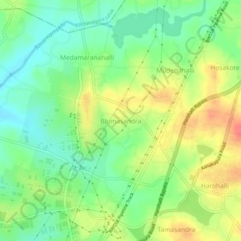
Name: Bhimasandra topographic map, elevation, terrain.
Average elevation: 688 m
Minimum elevation: 663 m
Maximum elevation: 720 m
Thank you for supporting this site ❤️
Make a donation
Make a donation
Other topographic maps
Click on a map to view its topography, its elevation and its terrain.
Bannerghatta National Park
India > Karnataka > Harohalli taluk > Gullahatti Kaval
The 65,127.5 acre (260.51 km2) national park is located about 22 km south of Bangalore in the hills of the Anekal range with an elevation of 1245 - 1634m. The park has a hilly terrain of granite sheets under moist deciduous forest valleys and scrubland on higher areas. Sixteen villages border the park. Most of…
Average elevation: 782 m