
Parroquia Ocumare del Tuy topographic map
Interactive map
Click on the map to display elevation.
About this map
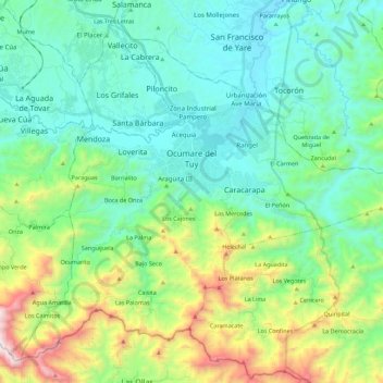
Name: Parroquia Ocumare del Tuy topographic map, elevation, terrain.
Average elevation: 448 m
Minimum elevation: 133 m
Maximum elevation: 1,423 m
Other topographic maps
Click on a map to view its topography, its elevation and its terrain.
Tuy
Venezuela > Estado Miranda > Municipio Lander > Los Grifales
Tuy, Los Grifales, Parroquia Santa Bárbara, Municipio Lander, Estado Miranda, 1212, Venezuela
Average elevation: 188 m