
Thank you for supporting this site ❤️
Make a donation
Make a donation
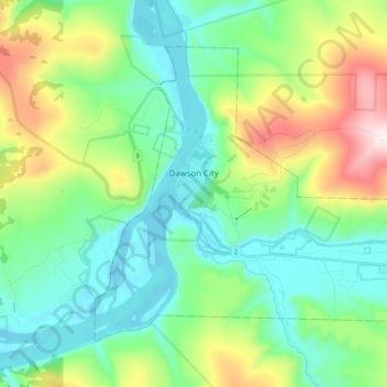
Dawson City topographic map
Click on the map to display elevation.
Thank you for supporting this site ❤️
Make a donation
Make a donation
Dawson City
The community is at an elevation of 320 m (1,050 ft) and the average rainfall in July is 49.0 mm (1.93 in) and the average snowfall in January is 27.6 cm (10.87 in). Dawson has an average total annual snowfall of 166.5 cm (65.55 in) and averages 70 frost free days per year. The town is built on a layer of frozen earth, which may pose a threat to the town's infrastructure in the future if the permafrost melts.
Thank you for supporting this site ❤️
Make a donation
Make a donation
About this map
Name: Dawson City topographic map, elevation, terrain.
Location: Dawson City, Yukon, Y0B 1G0, Canada (64.02198 -139.48364 64.08953 -139.28144)
Average elevation: 507 m
Minimum elevation: 300 m
Maximum elevation: 1,061 m
Thank you for supporting this site ❤️
Make a donation
Make a donation