
Make a donation
San Miguel Topilejo topographic map
Click on the map to display elevation.
Make a donation
About this map
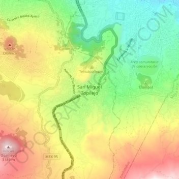
Name: San Miguel Topilejo topographic map, elevation, terrain.
Location: San Miguel Topilejo, Mexico City, 14500, Mexico (19.16131 -99.18167 19.24131 -99.10167)
Average elevation: 2,740 m
Minimum elevation: 2,275 m
Maximum elevation: 3,353 m
Make a donation
Other topographic maps
Click on a map to view its topography, its elevation and its terrain.
La Magdalena Contreras
La Magdalena Contreras (Spanish pronunciation: [maɣðaˈlena konˈtɾeɾas] ) is a borough (demarcación territorial) in the Mexico City. As of the 2010 census, it has a population of 239,086 inhabitants and is the third-least populous of Mexico City's boroughs. It lies at an elevation of 2,365 m (7,759 ft)…
Average elevation: 2,828 m
Make a donation
Milpa Alta
It has an average altitude of 2,420 meters above sea level with altitudes varying between 2,300 and 3,600. It is part of the Trans-Mexican Volcanic Belt and the Sierra Chichinautzin volcanic mountain chain, which separates Mexico City from the state of Morelos. The borough is divided into three zones:…
Average elevation: 2,842 m
Make a donation