
Thank you for supporting this site ❤️
Make a donation
Make a donation
Dayton topographic map
Click on the map to display elevation.
Thank you for supporting this site ❤️
Make a donation
Make a donation
About this map
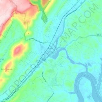
Name: Dayton topographic map, elevation, terrain.
Average elevation: 283 m
Minimum elevation: 202 m
Maximum elevation: 586 m
Thank you for supporting this site ❤️
Make a donation
Make a donation
Other topographic maps
Click on a map to view its topography, its elevation and its terrain.
Thank you for supporting this site ❤️
Make a donation
Make a donation
Mountain View
United States > Tennessee > Rhea County > Dayton > Mountain View
Average elevation: 276 m