
Thank you for supporting this site ❤️
Make a donation
Make a donation
Zembretta topographic map
Click on the map to display elevation.
Thank you for supporting this site ❤️
Make a donation
Make a donation
About this map
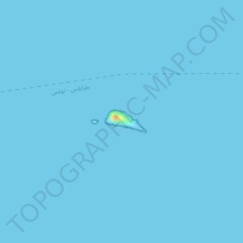
Name: Zembretta topographic map, elevation, terrain.
Location: Zembretta, Nabeul, Tunisia (37.10530 10.87195 37.10780 10.87762)
Average elevation: 0 m
Minimum elevation: 0 m
Maximum elevation: 34 m
Thank you for supporting this site ❤️
Make a donation
Make a donation
Other topographic maps
Click on a map to view its topography, its elevation and its terrain.
Thank you for supporting this site ❤️
Make a donation
Make a donation
Grombalia
Tunisia > Nabeul > قرنبالية الشرقية
Grombalia is located at an elevation of 102 meters above sea level and spans an area of 815.5 hectares. Its Latin name, "Hukulumbarros," translates to "traveling pigeon." Notably, Grombalia is characterized by its fertile lands and strategic geographical position in Cap Bon, making it a significant gateway to…
Average elevation: 60 m
Thank you for supporting this site ❤️
Make a donation
Make a donation
Thank you for supporting this site ❤️
Make a donation
Make a donation