
Make a donation
Halabja Governorate topographic map
Click on the map to display elevation.
Make a donation
Halabja Governorate
Halabja is located in the Shahrizor plain, a fertile valley nestled in the foothills of the Zagros Mountains in the Kurdistan Region of Iraq. The city's elevation is around 700 meters above sea level. The surrounding area is characterized by mountainous terrain, with the Hawraman Mountain range to the east, which plays a significant role in the city's climate and geography. The region's topography includes rolling hills and valleys, making it ideal for agriculture, particularly in the fertile plains.
Make a donation
About this map
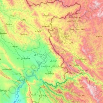
Name: Halabja Governorate topographic map, elevation, terrain.
Location: Halabja Governorate, Iraqi Kurdistan Region, Iraq (35.03802 45.79762 35.46053 46.20444)
Average elevation: 1,055 m
Minimum elevation: 447 m
Maximum elevation: 2,972 m
Make a donation
Other topographic maps
Click on a map to view its topography, its elevation and its terrain.
Make a donation
Make a donation
Make a donation
Make a donation
Umm al Binni lake
Based on the interpretation of satellite imagery, Sharad Master suggests the 3.4 km (2.1 mi) in diameter dry lake may be an impact crater based on its nearly circular, slightly polygonal rim shape, and contrasting shape to other lakes in the region. However, the circularity of its shape has been disputed, with…
Average elevation: 2 m
Make a donation
Make a donation
Halabja
Iraq > Halabja Governorate > Halabja District
Halabja is located in the Shahrizor plain, a fertile valley nestled in the foothills of the Zagros Mountains in the Kurdistan Region of Iraq. The city's elevation is around 700 meters above sea level. The surrounding area is characterized by mountainous terrain, with the Hawraman Mountain range to the east,…
Average elevation: 901 m
Make a donation
Make a donation
Make a donation
Make a donation
Make a donation
Ranya
Iraq > Sulaymaniyah Governorate
Ranya is located in the Sulaymaniyah Governorate in the Kurdistan Region of Iraq, approximately 70 km northeast of Sulaymaniyah city. It is situated near the Hawraman Mountains and lies at an altitude of about 1,300 meters.
Average elevation: 678 m
Make a donation
Make a donation
Make a donation
Make a donation
Make a donation
Make a donation
Make a donation
Make a donation
Shanadar cave
Iraq > Erbil Governorate > Mergasur District
The Shanidar Cave site is located near Rowanduz, positioned about 0.5 miles (800 m) from the Great Zab river, and situated at an elevation of 2,100 feet (640 m) above sea level. The cave’s entrance is triangular, and the portal is 82 feet (25 m) wide by 26 feet (7.9 m) high. The cave’s dimensions are 130…
Average elevation: 820 m
Make a donation
Make a donation
Make a donation
Make a donation
Make a donation
Make a donation