
Thank you for supporting this site ❤️
Make a donation
Make a donation
Battagram District topographic map
Click on the map to display elevation.
Thank you for supporting this site ❤️
Make a donation
Make a donation
About this map
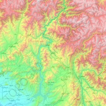
Name: Battagram District topographic map, elevation, terrain.
Location: Battagram District, Khyber Pakhtunkhwa, 21040, Pakistan (33.97217 72.32121 35.37217 73.72121)
Average elevation: 2,024 m
Minimum elevation: 285 m
Maximum elevation: 5,352 m
Thank you for supporting this site ❤️
Make a donation
Make a donation
Other topographic maps
Click on a map to view its topography, its elevation and its terrain.
Gantar Khwar
Pakistan > Khyber Pakhtunkhwa > Battagram District > Allai Tehsil > Palang
Average elevation: 2,082 m