
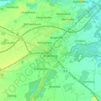
Plattling topographic map
Interactive map
Click on the map to display elevation.
About this map
Name: Plattling topographic map, elevation, terrain.
Location: Plattling, Landkreis Deggendorf, Bavaria, 94447, Germany (48.75282 12.84104 48.81069 12.96910)
Average elevation: 321 m
Minimum elevation: 311 m
Maximum elevation: 344 m
Other topographic maps
Click on a map to view its topography, its elevation and its terrain.
Mahd
Germany > Bavaria > Landkreis Deggendorf > Osterhofen > Arbing
Mahd, Arbing, Osterhofen, Landkreis Deggendorf, Bavaria, 94550, Germany
Average elevation: 311 m
Deggendorf
Germany > Bavaria > Landkreis Deggendorf
Deggendorf, Landkreis Deggendorf, Bavaria, 94469, Germany
Average elevation: 449 m
Neuhausen
Germany > Bavaria > Landkreis Deggendorf
Neuhausen, Offenberg, Landkreis Deggendorf, Bavaria, 94560, Germany
Average elevation: 341 m
Otzing
Germany > Bavaria > Landkreis Deggendorf
Otzing, Oberpöring (VGem), Landkreis Deggendorf, Bavaria, 94563, Germany
Average elevation: 328 m
Schuhreith
Germany > Bavaria > Landkreis Deggendorf > Mimming
Schuhreith, Mimming, Hengersberg, Landkreis Deggendorf, Bavaria, 94491, Germany
Average elevation: 337 m
Dobl
Germany > Bavaria > Landkreis Deggendorf
Dobl, Winzer, Landkreis Deggendorf, Bavaria, 94547, Germany
Average elevation: 378 m