
Make a donation
Badia - Abtei topographic map
Click on the map to display elevation.
Make a donation
About this map
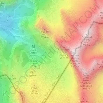
Name: Badia - Abtei topographic map, elevation, terrain.
Average elevation: 2,362 m
Minimum elevation: 1,729 m
Maximum elevation: 2,962 m
Make a donation
Other topographic maps
Click on a map to view its topography, its elevation and its terrain.
Compatsch
Italy > Trentino-Alto Adige/Südtirol > South Tyrol > Kastelruth - Castelrotto
Average elevation: 1,859 m
Neuwies - Pratonuovo
Italy > Trentino-Alto Adige/Südtirol > South Tyrol > Stilfs - Stelvio > Trafoi
Average elevation: 2,088 m
Make a donation
Similaun
Italy > Trentino-Alto Adige/Südtirol > South Tyrol > Schnals - Senales
Average elevation: 3,166 m
Marèo - Enneberg - Marebbe
Italy > Trentino-Alto Adige/Südtirol > South Tyrol
Average elevation: 1,879 m
Plan de Gralba
Italy > Trentino-Alto Adige/Südtirol > South Tyrol > Sëlva - Wolkenstein - Selva di Val Gardena
Average elevation: 2,095 m
Jenesien - San Genesio Atesino
Italy > Trentino-Alto Adige/Südtirol > South Tyrol
Average elevation: 1,136 m
Make a donation
Kurzras - Maso Corto
Italy > Trentino-Alto Adige/Südtirol > South Tyrol > Schnals - Senales
Average elevation: 2,457 m
Pragser Wildsee - Lago di Braies
Italy > Trentino-Alto Adige/Südtirol > South Tyrol > Prags - Braies
Average elevation: 1,744 m
Make a donation
Kohl
Italy > Trentino-Alto Adige/Südtirol > South Tyrol > Sarntal - Sarentino
Average elevation: 1,589 m
Piz dles Döes Forceles
Italy > Trentino-Alto Adige/Südtirol > South Tyrol > Badia - Abtei
Average elevation: 2,483 m
Seis am Schlern - Siusi allo Sciliar
Italy > Trentino-Alto Adige/Südtirol > South Tyrol > Kastelruth - Castelrotto
Average elevation: 1,211 m
Make a donation
Sankt Pankraz - San Pancrazio
Italy > Trentino-Alto Adige/Südtirol > South Tyrol
Average elevation: 1,385 m
Ciaminades
Italy > Trentino-Alto Adige/Südtirol > South Tyrol > Badia - Abtei
Average elevation: 1,634 m
St. Jakob - San Giacomo
Italy > Trentino-Alto Adige/Südtirol > South Tyrol > Laives - Leifers
Average elevation: 433 m
Make a donation
Rüdeferia
Italy > Trentino-Alto Adige/Südtirol > South Tyrol > Badia - Abtei
Average elevation: 1,740 m
St. Martin - San Martino in Casies
Italy > Trentino-Alto Adige/Südtirol > South Tyrol > Gsies - Valle di Casies > St. Martin - San Martino in Casies
Average elevation: 1,673 m
Passo dello Stelvio
Italy > Trentino-Alto Adige/Südtirol > South Tyrol > Stilfs - Stelvio
The Stelvio Pass (Italian: Passo dello Stelvio [passo ˈdello ˈstɛlvjo], Giogo dello Stelvio [dʒɔgo ˈdello ˈstɛlvjo]; German: Stilfser Joch; [ˈʃtɪlfsɐ jɔx]) is a mountain pass in northern Italy bordering Switzerland at an elevation of 2,757 m (9,045 ft) above sea level. It is the highest paved…
Average elevation: 2,724 m
Make a donation
Klockerkarkopf - Vetta d'Italia
Italy > Trentino-Alto Adige/Südtirol > South Tyrol > Predoi
Average elevation: 2,521 m
Fleins - Lines
Italy > Trentino-Alto Adige/Südtirol > South Tyrol > Freienfeld - Campo di Trens > Mauls - Mules
Average elevation: 1,367 m
Taufers im Münstertal - Tubre
Italy > Trentino-Alto Adige/Südtirol > South Tyrol > Taufers im Münstertal - Tubre
Average elevation: 1,919 m
Weißkugel - Palla Bianca
Italy > Trentino-Alto Adige/Südtirol > South Tyrol > Graun - Curon Venosta
Average elevation: 3,210 m
Make a donation
Kampill - Campiglio
Italy > Trentino-Alto Adige/Südtirol > South Tyrol > Bolzano - Bozen > Rentsch - Rencio > Kampill - Campiglio
Average elevation: 582 m
Gornerberg (Henne)
Italy > Trentino-Alto Adige/Südtirol > South Tyrol > Mühlwald - Selva dei Molini
Average elevation: 2,128 m
Make a donation
Prad am Stilfser Joch - Prato allo Stelvio
Italy > Trentino-Alto Adige/Südtirol > South Tyrol > Prad am Stilfserjoch - Prato allo Stelvio
Average elevation: 1,078 m