
Make a donation
Cerro La Hechicera topographic map
Click on the map to display elevation.
Make a donation
About this map
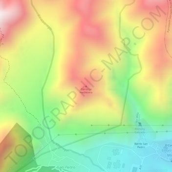
Name: Cerro La Hechicera topographic map, elevation, terrain.
Average elevation: 2,185 m
Minimum elevation: 1,792 m
Maximum elevation: 2,576 m
Make a donation
Other topographic maps
Click on a map to view its topography, its elevation and its terrain.
Parroquia Juan Rodríguez Suárez
Venezuela > Estado Mérida > Municipio Libertador
Average elevation: 1,463 m
Parroquia Mariano Picon Salas
Venezuela > Estado Mérida > Municipio Libertador
Average elevation: 1,780 m
Make a donation
Parroquia Gonzalo Picón Febres
Venezuela > Estado Mérida > Municipio Libertador
Average elevation: 3,219 m
Make a donation
Parroquia Antonio Spinetti Dini
Venezuela > Estado Mérida > Municipio Libertador
Average elevation: 1,869 m
Make a donation
Parroquia Mariano Picon Salas
Venezuela > Estado Mérida > Municipio Libertador
Average elevation: 1,780 m
Make a donation
Parroquia Caracciolo Parra Perez
Venezuela > Estado Mérida > Municipio Libertador
Average elevation: 1,531 m
Parroquia Gonzalo Picón Febres
Venezuela > Estado Mérida > Municipio Libertador
Average elevation: 3,219 m
Parroquia Antonio Spinetti Dini
Venezuela > Estado Mérida > Municipio Libertador
Average elevation: 1,869 m
Make a donation
Parroquia Mariano Picon Salas
Venezuela > Estado Mérida > Municipio Libertador
Average elevation: 1,780 m