
Batken topographic map
Interactive map
Click on the map to display elevation.
About this map
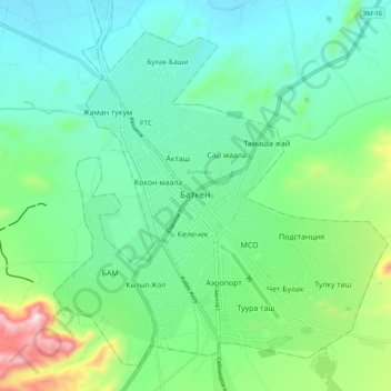
Name: Batken topographic map, elevation, terrain.
Location: Batken, Batken Region, 720105, Kyrgyzstan (40.02135 70.78175 40.10135 70.86175)
Average elevation: 1,064 m
Minimum elevation: 932 m
Maximum elevation: 1,471 m
Other topographic maps
Click on a map to view its topography, its elevation and its terrain.
Batken
Kyrgyzstan > Batken Region > Batken
Batken, Batken Region, Kyrgyzstan
Average elevation: 1,057 m