
Huangshan City topographic map
Interactive map
Click on the map to display elevation.
About this map
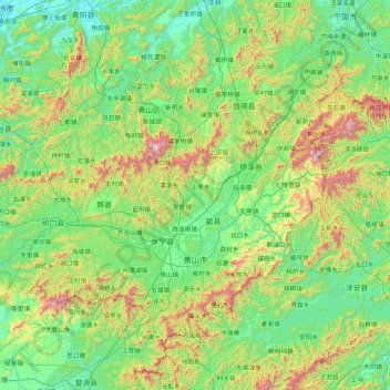
Name: Huangshan City topographic map, elevation, terrain.
Location: Huangshan City, Anhui, China (29.39523 117.19775 30.51954 118.89911)
Average elevation: 356 m
Minimum elevation: 5 m
Maximum elevation: 1,759 m
Lower elevations of Huangshan City have a humid subtropical climate (Köppen Cfa), with short, cool winters and long, very hot and humid summers. At the central Tunxi District, the monthly mean temperature ranges from 4.4 °C (39.9 °F) in January to 28.1 °C (82.6 °F) in July, and the annual mean is 16.66 °C (62.0 °F). Precipitation is concentrated in spring and the earlier part of summer, and, at 1,739 mm (68.5 in) annually, is very high for the province, and more than double than the normal annual precipitation in northern parts of the province.