
Thank you for supporting this site ❤️
Make a donation
Make a donation
Torgny topographic map
Click on the map to display elevation.
Thank you for supporting this site ❤️
Make a donation
Make a donation
About this map
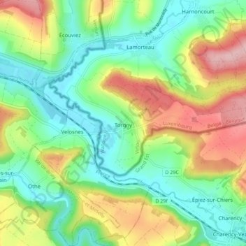
Name: Torgny topographic map, elevation, terrain.
Location: Torgny, Rouvroy, Virton, Luxembourg, Wallonie, Belgique (49.49698 5.44750 49.52090 5.53355)
Average elevation: 250 m
Minimum elevation: 184 m
Maximum elevation: 361 m
Thank you for supporting this site ❤️
Make a donation
Make a donation
Other topographic maps
Click on a map to view its topography, its elevation and its terrain.