
Thank you for supporting this site ❤️
Make a donation
Make a donation
Tamuning topographic map
Click on the map to display elevation.
Thank you for supporting this site ❤️
Make a donation
Make a donation
About this map
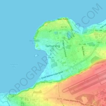
Name: Tamuning topographic map, elevation, terrain.
Location: Tamuning, Tamuning Municipality, Guam, United States (13.47859 144.75794 13.50893 144.80165)
Average elevation: 23 m
Minimum elevation: 0 m
Maximum elevation: 88 m
Thank you for supporting this site ❤️
Make a donation
Make a donation