
Poligny topographic map
Interactive map
Click on the map to display elevation.
About this map
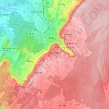
Name: Poligny topographic map, elevation, terrain.
Average elevation: 469 m
Minimum elevation: 239 m
Maximum elevation: 624 m
Other topographic maps
Click on a map to view its topography, its elevation and its terrain.
Ivory
France > Bourgogne-Franche-Comté > Jura
Ivory, Dole, Jura, Bourgogne-Franche-Comté, Metropolitan France, 39110, France
Average elevation: 577 m
La Combe
France > Bourgogne-Franche-Comté > Jura > Saint-Didier
La Combe, Saint-Didier, Lons-le-Saunier, Jura, Bourgogne-Franche-Comté, Metropolitan France, 39570, France
Average elevation: 274 m
Les Bouchoux
France > Bourgogne-Franche-Comté > Jura
Les Bouchoux, Saint-Claude, Jura, Bourgogne-Franche-Comté, Metropolitan France, 39370, France
Average elevation: 1,022 m
Lons-le-Saunier
France > Bourgogne-Franche-Comté > Jura
Lons-le-Saunier, Jura, Bourgogne-Franche-Comté, Metropolitan France, 39000, France
Average elevation: 303 m
Arbois
France > Bourgogne-Franche-Comté > Jura
Arbois, Dole, Jura, Bourgogne-Franche-Comté, Metropolitan France, 39600, France
Average elevation: 447 m
Foncine-le-Bas
France > Bourgogne-Franche-Comté > Jura
Foncine-le-Bas, Lons-le-Saunier, Jura, Bourgogne-Franche-Comté, Metropolitan France, 39520, France
Average elevation: 919 m
Clairvaux-les-Lacs
France > Bourgogne-Franche-Comté > Jura
Clairvaux-les-Lacs, Lons-le-Saunier, Jura, Bourgogne-Franche-Comté, Metropolitan France, 39130, France
Average elevation: 561 m
Vincent
France > Bourgogne-Franche-Comté > Jura > Vincent-Froideville
Vincent, Vincent-Froideville, Lons-le-Saunier, Jura, Bourgogne-Franche-Comté, Metropolitan France, 39230, France
Average elevation: 220 m
Château-Chalon
France > Bourgogne-Franche-Comté > Jura
Château-Chalon, Lons-le-Saunier, Jura, Bourgogne-Franche-Comté, Metropolitan France, 39210, France
Average elevation: 386 m
La Montagne au Paul
France > Bourgogne-Franche-Comté > Jura > Lajoux
La Montagne au Paul, Lajoux, Saint-Claude, Jura, Bourgogne-Franche-Comté, Metropolitan France, 39310, France
Average elevation: 1,161 m
Dramelay
France > Bourgogne-Franche-Comté > Jura
Dramelay, Lons-le-Saunier, Jura, Bourgogne-Franche-Comté, Metropolitan France, 39240, France
Average elevation: 461 m
Bellefontaine
France > Bourgogne-Franche-Comté > Jura > Bellefontaine
Bellefontaine, Saint-Claude, Jura, Bourgogne-Franche-Comté, Metropolitan France, 39400, France
Average elevation: 1,103 m
Charcier
France > Bourgogne-Franche-Comté > Jura > Charcier
Charcier, Lons-le-Saunier, Jura, Bourgogne-Franche-Comté, Metropolitan France, 39130, France
Average elevation: 535 m
La Tour-du-Meix
France > Bourgogne-Franche-Comté > Jura
La Tour-du-Meix, Lons-le-Saunier, Jura, Bourgogne-Franche-Comté, Metropolitan France, 39270, France
Average elevation: 500 m
Montrond
France > Bourgogne-Franche-Comté > Jura > Montrond
Montrond, Lons-le-Saunier, Jura, Bourgogne-Franche-Comté, Metropolitan France, 39300, France
Average elevation: 584 m
Les Rousses
France > Bourgogne-Franche-Comté > Jura > Les Rousses
Les Rousses, Saint-Claude, Jura, Bourgogne-Franche-Comté, Metropolitan France, 39220, France
Average elevation: 1,131 m
Crenans
France > Bourgogne-Franche-Comté > Jura > Crenans
Crenans, Saint-Claude, Jura, Bourgogne-Franche-Comté, Metropolitan France, 39260, France
Average elevation: 681 m
Rye
France > Bourgogne-Franche-Comté > Jura
Rye, Lons-le-Saunier, Jura, Bourgogne-Franche-Comté, Metropolitan France, 39230, France
Average elevation: 203 m
Châtillon
France > Bourgogne-Franche-Comté > Jura
Châtillon, Lons-le-Saunier, Jura, Bourgogne-Franche-Comté, Metropolitan France, 39130, France
Average elevation: 522 m
Baume-les-Messieurs
France > Bourgogne-Franche-Comté > Jura > Baume-les-Messieurs
Baume-les-Messieurs, Lons-le-Saunier, Jura, Bourgogne-Franche-Comté, Metropolitan France, France
Average elevation: 480 m
Saint-Claude
France > Bourgogne-Franche-Comté > Jura
Saint-Claude, Jura, Bourgogne-Franche-Comté, Metropolitan France, 39200, France
Average elevation: 814 m
Dole
France > Bourgogne-Franche-Comté > Jura
Dole, Jura, Bourgogne-Franche-Comté, Metropolitan France, 39100, France
Average elevation: 221 m