
Thank you for supporting this site ❤️
Make a donation
Make a donation
Choeng Mon topographic map
Click on the map to display elevation.
Thank you for supporting this site ❤️
Make a donation
Make a donation
About this map
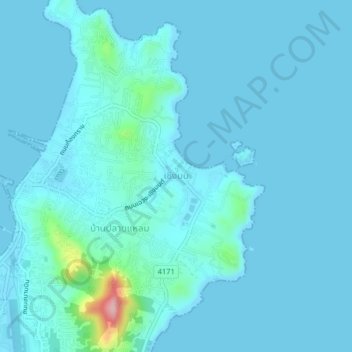
Name: Choeng Mon topographic map, elevation, terrain.
Location: Choeng Mon, Surat Thani Province, 84320, Thailand (9.55184 100.06088 9.59184 100.10088)
Average elevation: 15 m
Minimum elevation: -1 m
Maximum elevation: 183 m
Thank you for supporting this site ❤️
Make a donation
Make a donation
Other topographic maps
Click on a map to view its topography, its elevation and its terrain.
Bang Bua Thong Town Municipality
Thailand > Nonthaburi Province > Bang Bua Thong District
Average elevation: 4 m
Thank you for supporting this site ❤️
Make a donation
Make a donation
Ubon Ratchathani City Municipality
The elevation is 410 ft (125 m). It is 615 km (382 mi) from Bangkok.
Average elevation: 121 m
Thank you for supporting this site ❤️
Make a donation
Make a donation
Ban Luang Subdistrict Administrative Organization
Thailand > Phra Nakhon Si Ayutthaya Province
Average elevation: 5 m
Thank you for supporting this site ❤️
Make a donation
Make a donation
Thank you for supporting this site ❤️
Make a donation
Make a donation
Maha Phram Subdistrict Municipality
Thailand > Phra Nakhon Si Ayutthaya Province > Bang Ban District
Average elevation: 5 m