
North Glengarry topographic map
Interactive map
Click on the map to display elevation.
About this map
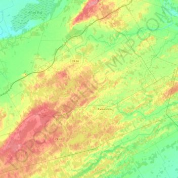
Name: North Glengarry topographic map, elevation, terrain.
Average elevation: 78 m
Minimum elevation: 44 m
Maximum elevation: 128 m
Other topographic maps
Click on a map to view its topography, its elevation and its terrain.
Morrisburg
Canada > Ontario > Stormont, Dundas and Glengarry Counties > South Dundas
Morrisburg, South Dundas, Stormont, Dundas and Glengarry Counties, Est de l'Ontario, Ontario, K0C 1X0, Canada
Average elevation: 79 m
South Glengarry
Canada > Ontario > Stormont, Dundas and Glengarry Counties
South Glengarry, Stormont, Dundas and Glengarry Counties, Est de l'Ontario, Ontario, Canada
Average elevation: 65 m