Geolocate

Molezon topographic map

Click on the map to display elevation.

About this map

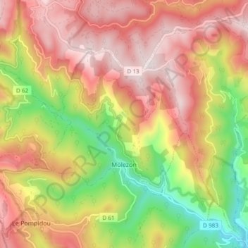
Name: Molezon topographic map, elevation, terrain.

Location: Molezon, Florac, Lozère, Occitania, Metropolitan France, 48110, France (44.19411 3.65360 44.23930 3.72849)

Average elevation: 715 m

Minimum elevation: 359 m

Maximum elevation: 1,005 m

Other topographic maps

Click on a map to view its topography, its elevation and its terrain.

Sauveplane

France > Occitania > Lozère

Average elevation: 463 m

Les Vanels

France > Occitania > Lozère > Vebron

Average elevation: 813 m

Le Coustat

France > Occitania > Lozère > Nasbinals

Average elevation: 1,202 m

Biffares

France > Occitania > Lozère > Saint-Alban-sur-Limagnole

Average elevation: 983 m

Lespartis

France > Occitania > Lozère > Peyre en Aubrac > Aumont-Aubrac

Average elevation: 1,047 m

La Roche

France > Occitania > Lozère > Lajo

Average elevation: 1,221 m

La Bastide

France > Occitania > Lozère > La Bastide-Puylaurent

Average elevation: 1,084 m