
Thank you for supporting this site ❤️
Make a donation
Make a donation
Dayu County topographic map
Click on the map to display elevation.
Thank you for supporting this site ❤️
Make a donation
Make a donation
About this map
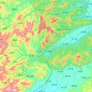
Name: Dayu County topographic map, elevation, terrain.
Location: Dayu County, Ganzhou, Jiangxi, China (25.25355 114.00209 25.62119 114.70206)
Average elevation: 416 m
Minimum elevation: 118 m
Maximum elevation: 1,380 m
Thank you for supporting this site ❤️
Make a donation
Make a donation
Other topographic maps
Click on a map to view its topography, its elevation and its terrain.