
Groß Nikobar topographic map
Interactive map
Click on the map to display elevation.
About this map
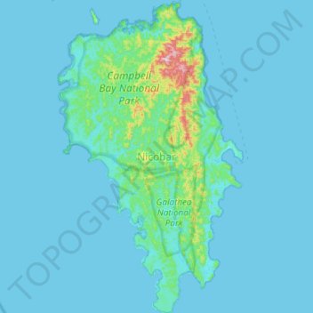
Name: Groß Nikobar topographic map, elevation, terrain.
Location: Groß Nikobar, Nicobar, Andamanen und Nikobaren, Indien (6.75633 93.65653 7.24387 93.94684)
Average elevation: 32 m
Minimum elevation: 0 m
Maximum elevation: 608 m
Other topographic maps
Click on a map to view its topography, its elevation and its terrain.
South Andaman
Indien > Andamanen und Nikobaren
South Andaman, Andamanen und Nikobaren, Indien
Average elevation: 3 m
North and Middle Andaman
Indien > Andamanen und Nikobaren
North and Middle Andaman, Andamanen und Nikobaren, 744210, Indien
Average elevation: 4 m