
Schwarzenberg topographic map
Interactive map
Click on the map to display elevation.
About this map
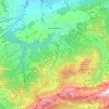
Name: Schwarzenberg topographic map, elevation, terrain.
Location: Schwarzenberg, Lucerne, Suisse (46.96348 8.12722 47.02909 8.23771)
Average elevation: 1,053 m
Minimum elevation: 515 m
Maximum elevation: 2,058 m
Other topographic maps
Click on a map to view its topography, its elevation and its terrain.
Tellenmoos
Suisse > Lucerne > Escholzmatt-Marbach
Tellenmoos, Escholzmatt-Marbach, Lucerne, 6182, Suisse
Average elevation: 915 m
Hochwäldli
Suisse > Lucerne > Schwarzenberg
Hochwäldli, Schwarzenberg, Lucerne, 6013, Suisse
Average elevation: 895 m
Ebersecken
Suisse > Lucerne > Ebersecken
Ebersecken, Altishofen, Lucerne, 6246, Suisse
Average elevation: 639 m
UNESCO Biosphère d'Entlebuch
UNESCO Biosphère d'Entlebuch, Flühli, Lucerne, 6173, Suisse
Average elevation: 1,145 m