
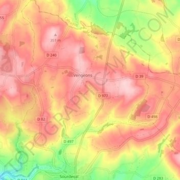
Vengeons topographic map
Interactive map
Click on the map to display elevation.
About this map
Name: Vengeons topographic map, elevation, terrain.
Average elevation: 279 m
Minimum elevation: 158 m
Maximum elevation: 354 m
Other topographic maps
Click on a map to view its topography, its elevation and its terrain.
La Bruyère de Haut
France > Normandie > Manche > Sourdeval
La Bruyère de Haut, Sourdeval, Avranches, Manche, Normandie, France métropolitaine, 50150, France
Average elevation: 224 m
La Mazure aux Uriens
France > Normandie > Manche > Sourdeval
La Mazure aux Uriens, Sourdeval, Avranches, Manche, Normandie, France métropolitaine, 50150, France
Average elevation: 215 m
La Thébaudière
France > Normandie > Manche > Sourdeval
La Thébaudière, Sourdeval, Avranches, Manche, Normandie, France métropolitaine, 50150, France
Average elevation: 244 m
La Mare Pinet
France > Normandie > Manche > Sourdeval
La Mare Pinet, Sourdeval, Avranches, Manche, Normandie, France métropolitaine, 50150, France
Average elevation: 216 m