
Make a donation
Harrison Hot Springs topographic map
Click on the map to display elevation.
Make a donation
About this map
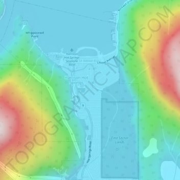
Name: Harrison Hot Springs topographic map, elevation, terrain.
Average elevation: 203 m
Minimum elevation: 1 m
Maximum elevation: 840 m
Make a donation
Other topographic maps
Click on a map to view its topography, its elevation and its terrain.
Harrison Mills
Canada > British Columbia > Fraser Valley Regional District > Kent
Average elevation: 54 m
Durieu
Canada > British Columbia > Fraser Valley Regional District > Area F (McConnell Creek/Hatzic Prairie)
Average elevation: 142 m
Ryder Lake
Canada > British Columbia > Fraser Valley Regional District > Chilliwack
Average elevation: 255 m
Make a donation
Abbotsford
Canada > British Columbia > Fraser Valley Regional District > Abbotsford
Average elevation: 115 m
Stone Garden
Canada > British Columbia > Fraser Valley Regional District > Area B (South Fraser Canyon/Sunshine Valley)
Average elevation: 319 m
Skook Jim Mountain
Canada > British Columbia > Fraser Valley Regional District > Area C (Sasquatch Country)
Average elevation: 2,216 m