
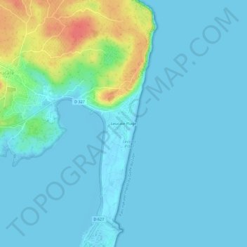
Leucate-Plage topographic map
Interactive map
Click on the map to display elevation.
About this map
Name: Leucate-Plage topographic map, elevation, terrain.
Average elevation: 10 m
Minimum elevation: -4 m
Maximum elevation: 58 m
Other topographic maps
Click on a map to view its topography, its elevation and its terrain.
Port-Leucate
France > Occitanie > Aude > Leucate
Port-Leucate, Leucate, Narbonne, Aude, Occitanie, France métropolitaine, 11370, France
Average elevation: 0 m
La Franqui
France > Occitanie > Aude > Leucate
La Franqui, Leucate, Narbonne, Aude, Occitanie, France métropolitaine, 11370, France
Average elevation: 15 m
Phare de Leucate
France > Occitanie > Aude > Leucate
Phare de Leucate, Chemin du Phare, Leucate, Narbonne, Aude, Occitanie, France métropolitaine, 11370, France
Average elevation: 15 m