
Ballycroy topographic map
Click on the map to display elevation.
About this map
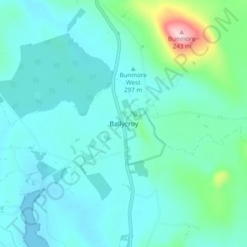
Name: Ballycroy topographic map, elevation, terrain.
Average elevation: 36 m
Minimum elevation: -1 m
Maximum elevation: 236 m
Other topographic maps
Click on a map to view its topography, its elevation and its terrain.
Westport
The first clear evidence for the development of the new town is in an advertisement in Faulkner's Dublin Journal on 17 March 1767, stating 'a New Town is immediately to be built near the old town of Westport...according to Plans and Elevations already prepared'. The focal point was to be a 'large and elegant…
Average elevation: 44 m