
Virgin Gorda topographic map
Interactive map
Click on the map to display elevation.
About this map
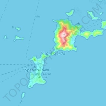
Name: Virgin Gorda topographic map, elevation, terrain.
Location: Virgin Gorda, British Virgin Islands (18.42517 -64.44682 18.50568 -64.31996)
Average elevation: 11 m
Minimum elevation: -1 m
Maximum elevation: 404 m
Other topographic maps
Click on a map to view its topography, its elevation and its terrain.
Virgin Gorda
British Virgin Islands > Olde Yard Village
Virgin Gorda, Olde Yard Village, VG115, British Virgin Islands
Average elevation: 11 m