
Thank you for supporting this site ❤️
Make a donation
Make a donation
Leugnies topographic map
Click on the map to display elevation.
Thank you for supporting this site ❤️
Make a donation
Make a donation
About this map
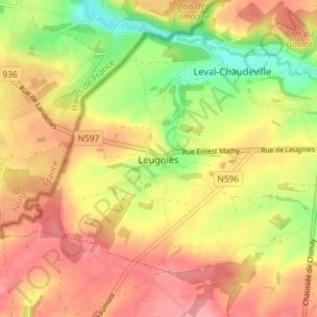
Name: Leugnies topographic map, elevation, terrain.
Location: Leugnies, Thuin, Hainaut, Wallonie, 6500, Belgique (50.20450 4.17617 50.24450 4.21617)
Average elevation: 201 m
Minimum elevation: 143 m
Maximum elevation: 244 m
Thank you for supporting this site ❤️
Make a donation
Make a donation
Other topographic maps
Click on a map to view its topography, its elevation and its terrain.