
Thank you for supporting this site ❤️
Make a donation
Make a donation
L'Orbrie topographic map
Click on the map to display elevation.
Thank you for supporting this site ❤️
Make a donation
Make a donation
About this map
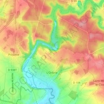
Name: L'Orbrie topographic map, elevation, terrain.
Average elevation: 63 m
Minimum elevation: 8 m
Maximum elevation: 110 m
Thank you for supporting this site ❤️
Make a donation
Make a donation
Other topographic maps
Click on a map to view its topography, its elevation and its terrain.
Logis Du Fenestreau
France > Pays de la Loire > Vendée > Les Sables-d'Olonne > Les Soulardières
Average elevation: 31 m
L'Égronnière
France > Pays de la Loire > Vendée > Montaigu-Vendée > Saint-Hilaire-de-Loulay
Average elevation: 42 m
Thank you for supporting this site ❤️
Make a donation
Make a donation