
Make a donation
Mauer topographic map
Click on the map to display elevation.
Make a donation
Mauer
Mauer is located at an altitude of 130–240 m, and covers an area of 630 hectares. Of this area, 22.8% is covered by settlements, roads and paved areas, 55.3% is agricultural, and 18.6% is forested. Adjacent municipalities are, starting in the north and moving clockwise, Wiesenbach, Meckesheim, Wiesloch, Leimen and Bammental.
Make a donation
About this map
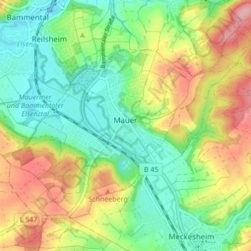
Name: Mauer topographic map, elevation, terrain.
Average elevation: 175 m
Minimum elevation: 123 m
Maximum elevation: 254 m
Make a donation
Other topographic maps
Click on a map to view its topography, its elevation and its terrain.
Sinsheim-Steinsfurt / Insenbach
Germany > Baden-Württemberg > Rhein-Neckar-Kreis > Sinsheim
Average elevation: 204 m
Gauangelloch
Germany > Baden-Württemberg > Rhein-Neckar-Kreis > Leimen > Gauangelloch
Average elevation: 221 m
Neckar-Wimmersbach
Germany > Baden-Württemberg > Rhein-Neckar-Kreis > Eberbach
Average elevation: 256 m