
Thank you for supporting this site ❤️
Make a donation
Make a donation
Dampremy topographic map
Click on the map to display elevation.
Thank you for supporting this site ❤️
Make a donation
Make a donation
About this map
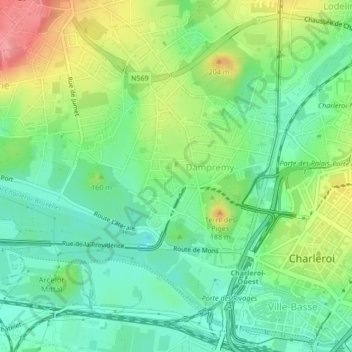
Name: Dampremy topographic map, elevation, terrain.
Location: Dampremy, Charleroi, Hainaut, Wallonie, 6020, Belgique (50.40750 4.40820 50.42836 4.44311)
Average elevation: 122 m
Minimum elevation: 87 m
Maximum elevation: 178 m
Thank you for supporting this site ❤️
Make a donation
Make a donation
Other topographic maps
Click on a map to view its topography, its elevation and its terrain.