
Thank you for supporting this site ❤️
Make a donation
Make a donation
Les Martins topographic map
Click on the map to display elevation.
Thank you for supporting this site ❤️
Make a donation
Make a donation
About this map
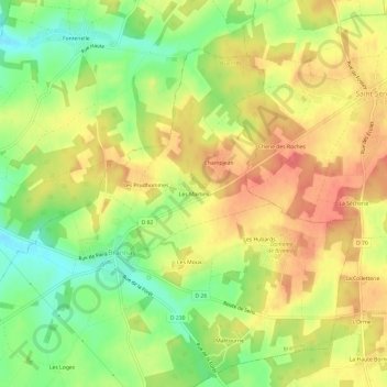
Name: Les Martins topographic map, elevation, terrain.
Average elevation: 170 m
Minimum elevation: 136 m
Maximum elevation: 197 m
Thank you for supporting this site ❤️
Make a donation
Make a donation
Other topographic maps
Click on a map to view its topography, its elevation and its terrain.
Domaine de Brannay
France > Bourgogne-Franche-Comté > Yonne > Brannay > Les Hubards
Average elevation: 177 m