
Thank you for supporting this site ❤️
Make a donation
Make a donation
Werribee River topographic map
Click on the map to display elevation.
Thank you for supporting this site ❤️
Make a donation
Make a donation
About this map
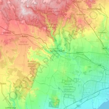
Name: Werribee River topographic map, elevation, terrain.
Location: Werribee River, Victoria, Australia (-37.97396 144.15651 -37.43326 144.68764)
Average elevation: 281 m
Minimum elevation: -1 m
Maximum elevation: 874 m
Thank you for supporting this site ❤️
Make a donation
Make a donation
Other topographic maps
Click on a map to view its topography, its elevation and its terrain.
Thank you for supporting this site ❤️
Make a donation
Make a donation