
Thank you for supporting this site ❤️
Make a donation
Make a donation
Munting Ilog topographic map
Click on the map to display elevation.
Thank you for supporting this site ❤️
Make a donation
Make a donation
About this map
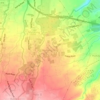
Name: Munting Ilog topographic map, elevation, terrain.
Location: Munting Ilog, Silang, Cavite, Calabarzon, 4118, Philippines (14.19904 120.97607 14.23904 121.01607)
Average elevation: 309 m
Minimum elevation: 215 m
Maximum elevation: 368 m
Thank you for supporting this site ❤️
Make a donation
Make a donation
Other topographic maps
Click on a map to view its topography, its elevation and its terrain.