
Floridsdorf topographic map
Interactive map
Click on the map to display elevation.
About this map
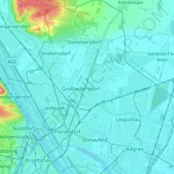
Name: Floridsdorf topographic map, elevation, terrain.
Location: Floridsdorf, Wien, 1210, Österreich (48.23635 16.35596 48.32267 16.47474)
Average elevation: 177 m
Minimum elevation: 153 m
Maximum elevation: 399 m
Other topographic maps
Click on a map to view its topography, its elevation and its terrain.
KG Meidling
Österreich > Wien > Wien
KG Meidling, Meidling, Wien, 1120, Österreich
Average elevation: 208 m
KG Fünfhaus
Österreich > Wien > Wien
KG Fünfhaus, Rudolfsheim-Fünfhaus, Wien, 1150, Österreich
Average elevation: 211 m