
Камско-Устьинский район topographic map
Interactive map
Click on the map to display elevation.
About this map
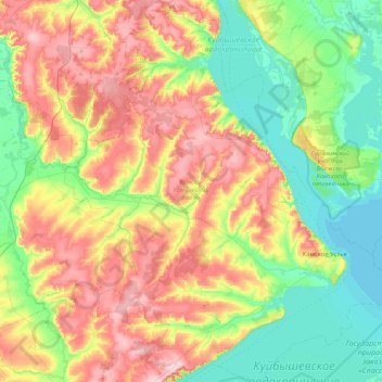
Name: Камско-Устьинский район topographic map, elevation, terrain.
Average elevation: 115 m
Minimum elevation: 45 m
Maximum elevation: 234 m
Other topographic maps
Click on a map to view its topography, its elevation and its terrain.
Nischnekamsker Stausee
Russland > Tatarstan > Малошильнинское сельское поселение
Nischnekamsker Stausee, Малошильнинское сельское поселение, Тукаевский район, Tatarstan, Föderationskreis Wolga, Russland
Average elevation: 129 m