
Make a donation
Castile and León topographic map
Click on the map to display elevation.
Make a donation
Castile and León
The morphology of Castile and León consists, for the most part, of the northern half of the Meseta Central (Meseta Norte) and a belt of mountainous reliefs. The Meseta Central is a high plateau with an average altitude close to 800 m (2,600 ft) above sea-level; it is covered by deposited clay materials that have given rise to a dry and arid landscape.
Make a donation
About this map
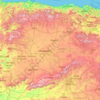
Name: Castile and León topographic map, elevation, terrain.
Location: Castile and León, Spain (40.08245 -7.07707 43.23820 -1.77537)
Average elevation: 788 m
Minimum elevation: -1 m
Maximum elevation: 2,468 m
Make a donation
Other topographic maps
Click on a map to view its topography, its elevation and its terrain.
Make a donation
Make a donation
Make a donation
Arrutiegia
Spain > Autonomous Community of the Basque Country > Urola-Kosta > Aia
Average elevation: 223 m
Make a donation
Las Vagas
Spain > Aragon > Cuencas Mineras > Martín del Río > La Rambla de Martín
Average elevation: 1,120 m
Make a donation
Urbanització Cala Llonga
Spain > Balearic Islands > Ibiza > Santa Eulària des Riu
Average elevation: 39 m
Make a donation
Make a donation
Make a donation
Donostia / San Sebastián
Spain > Autonomous Community of the Basque Country > Donostialdea > Donostia / San Sebastián
Average elevation: 134 m
Make a donation
Madrid
Spain > Community of Madrid > Área metropolitana de Madrid y Corredor del Henares > Madrid
Average elevation: 650 m
Urbanización Doña Pepa
Spain > Valencian Community > Rojales > Urbanización Doña Pepa
Average elevation: 24 m
Make a donation
Murcia
Spain > Region of Murcia > Region of Murcia > Murcia
Murcia is located near the center of a low-lying fertile plain known as the huerta (orchard or vineyard) of Murcia. The Segura River and its right-hand tributary, the Guadalentín, run through the area. The city has an elevation of 43 metres (141 ft) above sea level and its municipality covers approximately…
Average elevation: 169 m
Make a donation
El Port de la Selva
Spain > Catalonia > Upper Empordà > el Port de la Selva > El Port de la Selva
Average elevation: 76 m
Make a donation
Pollença
Spain > Balearic Islands > Serra de Tramuntana > Pollença > Pollença
Average elevation: 156 m
Make a donation
Make a donation
Presa de Majarobledo
Spain > Extremadura > Las Hurdes > Casares de las Hurdes
Average elevation: 1,080 m